| Quick Facts: | Great Salt Lake |
|---|---|
| Country: | USA |
| Generally Salinity: | 27% |
| Catchment area: | 21.500 sq mi (55.685 km²) |
| Surface Area: | 1.700 sq mi (4.400 km²) |
| Max. length: | 75 mi (120 km) |
| Max. width: | 28 mi (45 km) |
| Avg. Depth: | 16 ft (4.9 m) |
| Max. Depth: | 1987: 33 ft (10 m) avg high of 45 ft (14 m) |
| 1963: | low of 24 ft (7.3 m) |
| Water volume: | 18.92 km³ |
| Main Rivers: | Bear Jordan Weber rivers |
| Lake Type: | Endorheic & hypersaline |
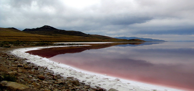
Great Salt Lake is a broad, shallow, saline inland sea in northwestern Utah, lying just west of the Wasatch Mountains and east of the Great Salt Lake Desert. Rather rectangular in shape, the lake stretches 72 miles (115 km) in a southeast-northwest direction and is about 30 miles (50 km) wide at its widest point. It is fed by the Jordan, Weber, and Bear rivers. Its maximum depth is about 35 feet (11 meters). Salt Lake City, the state capital, is about 5 miles (8 km) southeast of the lake.
The lake’s elevation and surface area have fluctuated considerably, owing to variations in precipitation and evaporation. On average the surface of Great Salt Lake is approximately 4,200 feet (1,280 meters) above sea level and its surface area covers about 1,700 square miles (4,400 sq km). In 1963, however, it reached a record low, 4,191 feet (1,277 meters), and covered only 950 square miles (2,460 sq km).
The lake then expanded in 1986–1987, to a historic high—4,212 feet (1,284 meters) above sea level and covering an area of 3,300 square miles (8,550 sq km)—before receding once again. Part of the water from the streams feeding the lake is diverted for agricultural, industrial, and residential purposes.
Wildlife
Small islets in Great Salt Lake are nesting places for seagulls, blue herons, double-crested cormorants, and Caspian terns. Buffalo, deer, and antelope live on Antelope Island, near the southern shore. The lake itself is not entirely devoid of living things, despite the bitter lake brine. The visible forms of life are the brine shrimp, Artemia graciles, the adult and pupa of the fly Ephydra, and the blue-green colonial algae Aphanothece parchardii.
Resources
Great Salt Lake, which is several times more saline than seawater, contains about 4.5 to 4.9 billion tons of minerals. These are primarily common salt (sodium chloride) but also include magnesium, potassium, sulfate, and carbonate. The lake’s salinity has varied between 15.1% and 28.8% of dissolved solids. About 2.2 million tons of salts are added to the lakeannually by inflows of ground- and surface water, while 2.5 million tons are extracted by industry. Large-scale production of magnesium commenced in 1971. The eggs of brine shrimp are harvested from the surface and used worldwide as a fish food in aquaculture. Potash is extracted primarily from the nearby Bonneville Salt Flats.
The History of Great Salt Lake
Great Salt Lake is the remnant of the glacial Lake Bonneville, which came into existence 18,000 to 25,000 years ago. At its maximum development the ancient lake covered 20,000 square miles (51,800 sq km) and had a depth of 1,000 feet (300 meters).
In the cool, moist climate of the glacial period, precipitation filled the great Bonneville basin. Eventually thelake overflowed the basin’s rim at Red Rock Pass in southern Idaho and poured into the drainage of the Snake River.
With the return of a warm, dry climate, the lake gradually retreated to its present size. In 1776, two Spanish priests, Silvestre Vélez de Escalante and Francisco Atanasio Domínguez, heard of the lake and its saline composition.
However, the first white man actually to see the lake was the fur trapper Jim Bridger, who floated down the Bear River in a buffalo-hide boat in late 1824. The lake soon became well known to explorers and trappers. In 1843 and 1845, Col. John C. Frémont made scientific reconnaissances there. In 1849 and 1850, Capt. Howard Stansbury prepared an excellent map of the lake and named many of its features. Both Frémont and Stansbury were exploring and surveying for the U.S. Army.
In the 1950s the Southern Pacific Railroad built a rock-filled causeway across the lake to replace a wooden trestle that had become unstable. The causeway restricted the circulation of water between the northern and southern arms of the lake.
Receiving most of the fresh river water, the southern arm rose to a higher level than the northern and became approximately half as salty. In order to reduce flooding, a 300-foot (90-meter) breach was made in the causeway in 1984, which mitigated but did not eliminate differences between the two arms.After continued flooding, a pumping station was built in 1987 to pump excess water into the desert.


